
Suburban communities have been developed to give residents quiet locations to live and thrive, away from the hustle and bustle of city centers. Time and time again, such communities have been built with roads with fine curvatures and "stems and branches" designed to maximize the privacy found in individual neighborhoods. However, an unintended consequence of suburban development is that sometimes, when planners want to develop new services to serve nearby neighborhoods, chances are gaps can be found between them. Sometimes, such gaps can result in long drives or walking distances just to get from one place to another that, if we take it from a bird's eye view, it would only take a few seconds to cross from one property to another. How can such planning mistakes be rectified, especially if we aim to address various issues governing accessibility, congestion, and connectivity?
In this series, I am going to explore a short, yet missing crucial link that could address congestion in a corner of San Mateo County, linking Foster City and Redwood Shores.
In this series, I am going to explore a short, yet missing crucial link that could address congestion in a corner of San Mateo County, linking Foster City and Redwood Shores.
Lately, a friend of mine suggested reviving a former SamTrans express line, Route FX. Route FX was discontinued in 2010 (along with multiple other express lines, including the CX, DX, MX, PX, and RX) due to budget cuts as a result of the Great Recession. That bus service used to operate between Foster City and San Francisco, operating through the Financial District and served many residential neighborhoods in Foster City and San Mateo. Not to mention, the area surrounding Foster City and Redwood Shores is served by multiple local SamTrans lines, namely Routes 251, 256, 260, and 261.
- Routes 251 and 256 operate as loop lines between Hillsdale Mall and Foster City, serving Hillsdale Caltrain station and multiple attractions in Foster City, from Costco to Civic Center. These operate Mondays to Saturdays, with no holiday service.
- Route 260 operates between College of San Mateo and San Carlos Caltrain via Ralston Avenue, Belmont Caltrain, and Redwood Shores, with select trips operating via County Youth Center and Gateway Center. This operates weekdays only, with no holiday service.
- Route 261 operates as a truncated version of Route 260 between Continentals & Lyall in Belmont and San Carlos Caltrain via Belmont Caltrain and Bridge Blvd. in Redwood Shores. This operates Saturdays only, with no holiday service.
Given that none of the routes operate on Sundays or holidays, and that the area is heavily car-dependent, it got me thinking: what is wrong with the overall road network that severely limits transit opportunities and overall circulation in San Mateo, Foster City, and San Carlos? What I found on Google Maps is a missing crucial link between Edgewater Blvd. in Foster City and Island Drive in Redwood Shores. The yellow shade on the map indicates my idea to develop a bridge linking the two roadways.
 | 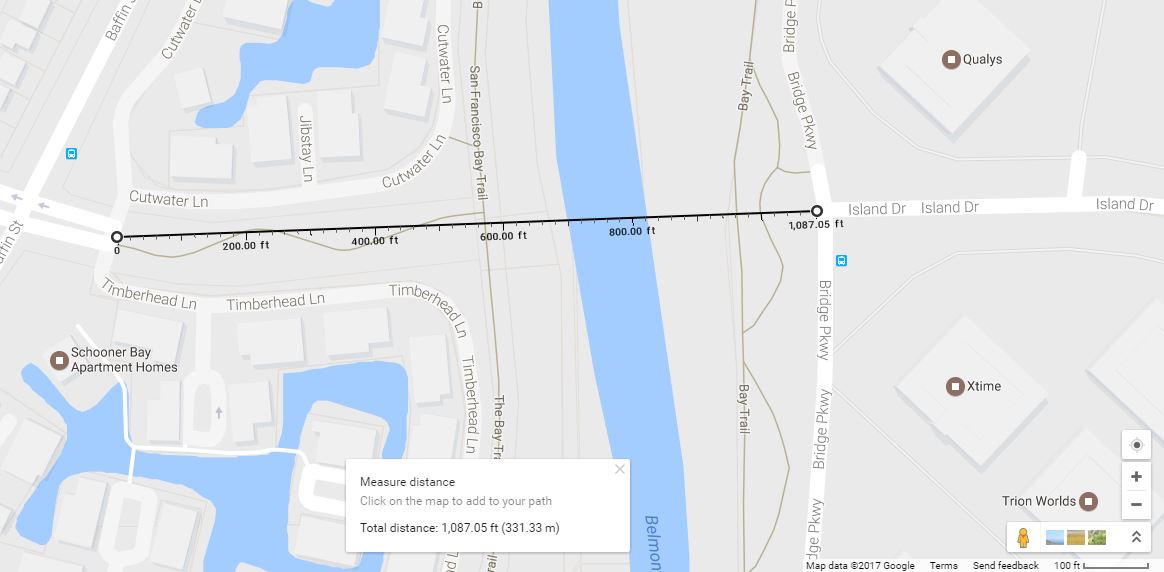 |
Indeed, while the overall length may be under 1,100 feet, this missing link can address many of the circulation concerns found between the three cities. At the moment, if one wants to travel between Foster City and Redwood Shores, there are a few options:
- Drive around 6 miles for 12 minutes without traffic via US-101
- Walk for around 30 minutes
- Bike for around 9 minutes
 |  |  |
Challenges
Some of the initial challenges I can foresee with this plan include opposition from residents in Foster City, especially with additional congestion and noise; concerns governing sea level rise (given its proximity to San Francisco Bay); access to Schooner Bay may be hampered; and differing road widths once the bridge lands on Island Drive. While the Foster City section can be difficult enough to address (especially with the presence of a bike lane and a bike trail), the landing at Island & Bridge can be more challenging, especially that Island Drive is narrower than Edgewater Boulevard. I will discuss more of the challenges once I get traction on this development.
Road Diet: A Possible Solution?
Given the suburban nature of Edgewater Boulevard, it has a generous right-of-way at 80 feet, with 13-foot lanes and a 17-foot median with large overhead lights. With the bridge, I am looking to develop a road diet along the corridor that includes:
The rationale for setting the road diet on the bridge include:
- Bike lanes in either direction (6 feet)
- Expanding the sidewalks by up to 3 feet per direction, with the extra space being allocated for benches and other touches to complement the tall trees that line the roadway
- Shrinking the median to 10 feet
- Reducing the lane widths to 10 feet each
- Restrictions on trucks heavier than 7 tons
The rationale for setting the road diet on the bridge include:
- Safer speeds among vehicles, lowering the chance of overspeeding
- More opportunities for cyclists and pedestrians to use the roadway and travel between San Mateo, Foster City, and San Carlos
- Lower speeds can make the neighbors feel safer
 Current road diet |  Proposed road diet | 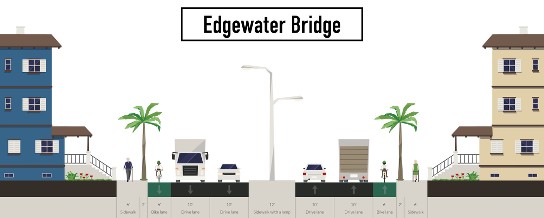 Edgewater Bridge Road Diet |
Next Steps
Some of my next steps include:
Perhaps this could be the start of my thesis paper that I will write towards the end of my graduate course at San Jose State University.
- Deeper analysis on the chosen road diet, as well as alternatives
- Potential transit lines that will use the bridge
- How the bridge will improve connectivity in San Mateo, Foster City, San Carlos, and beyond
- Funding for its development, environmental analyses, and construction
- Discussions with officials from San Mateo County, the city governments involved in this development, San Mateo County Transit District, and other key stakeholders
Perhaps this could be the start of my thesis paper that I will write towards the end of my graduate course at San Jose State University.
